Stable Boy has a pretty hectic work schedule, but I try to drag him out riding with me once or twice a season. Sometimes it's just around the house. A few years ago we did a moonlit ride at the St. Anthony Sand Dunes. Last year I took him on his first trail ride in the mountains--an 11 hour ride up and over Hurricane Pass. It was kind of like throwing someone into a pond--you either sink or swim. There are some fairly steep switchbacks with sheer drop-offs where the trail was just wide enough for the horse to walk. Shh, don't tell, but I'm pretty sure I heard him say a bad word at one point. Somehow those drop-offs seem a lot steeper from the back of a horse.
This time we opted to go to Union Falls in Yellowstone. I've wanted to go there for years, but it never worked out till now. For those of you who don't spend a lot of time in the back country, in a lot of places Forest Service Roads are not very well marked. I'd heard finding the turnoff to the trail head could be tricky, so I got directions from a friend and pulled out my handi-dandy National Geographic Trails Illustrated Map and off we went.
Both the directions and the map were in agreement that we needed to turn on left on FS 048 to get to the trail head. We focused carefully on each left turn but never found one labeled 048. At one point we passed a road with a tree encircled with bright pink ribbons, but that one was labeled FS 022, so on we went, crawling along at 10 mph over one of the most bumpy dirt roads I've ever been on. By the time we reached a recognizable land mark on the map, both of us realized that we had somehow missed the turn-off in spite of our care. We retraced our route back and still couldn't find the correct road.
I finally suggested that we go back and try going up the road that had been flagged with ribbons, even thought the road signs didn't match up. Sure enough, it was the right road. For some inexplicable reason, the Forest Service had changed the road name. I had planned to be on the trail by 10:30 or 11 am at the latest, but with all of our doubling back and forth, it was 1:15 pm before we left the trailer.
Since we were supposed to be at Kid 4's Back-to-School Night that evening, we really had to hustle. We scrapped our original plan to go swimming at the base of the falls and focused on getting there and back as quickly as possible. It took us less than 4.5 hours to cover approximately 20 miles round trip. That included tying up the horses near the falls and hiking up to the falls view point and back down. I have to say that Union Falls is one of the most beautiful I've ever seen. Well worth the trip! I would love to go back so we can swim and explore without feeling so rushed.
We made it back just in time to catch most of Kid 4's teacher's last presentation. Funny thing--I had been able to get a text out to the kids so they knew we were running late. Kid 2 wasn't sure we would return in time, so she took it upon herself to take Kid 4 to BTSN so he wouldn't miss it. They were turning their bikes onto our road to head home as we drove past (horses, spurs, dirt and all) to go to the school. She's so sweet!
Now, for anyone else wanting to go to Union Falls, here are the true directions.
True Directions to Union Falls
From Rexburg, head north on HWY 20. About 1 miles south of Ashton, turn East on 1200 N (by the Squirrel Creek sign). Continue east--you will reach the junction of Forest Service Roads 261 and 264 at 25.5 miles. Continue on for another 3 miles (for a total of 28.5 miles) until you reach Forest Service 022 (the former FS 048). Turn left.
Drive 0.2 miles till the road splits. At this point you can either park in the grassy meadows and ride about a mile to the trail head; or you can continue down the extremely rough Forest Service 023 (formerly FS 047) to the Fish Lake trail head.
We started to drive down 023, but opted to back out to the meadows because we were afraid we might damage the trailer hitch with all of the dips and huge water-filled pot holes.
FYI-The trail head is about 1.5 hours from Rexburg. The last 14.7 miles of your trip will be on a dirt road. Plan on at least 45 minutes of drive time from where the pavement ends to the trail head.
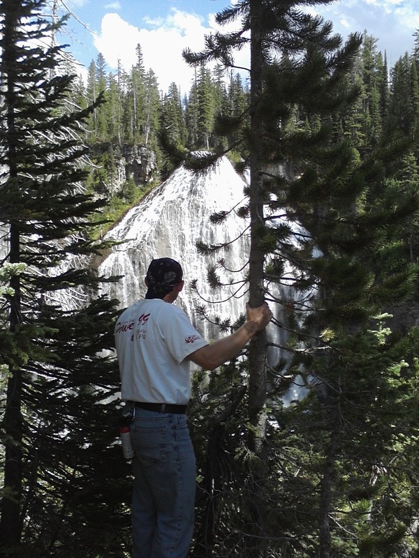
Stable Boy overlooking Union Falls.
 RSS Feed
